Resilient PNT - FAQ Part 1
Q: “Resilient PNT” is a relatively new buzzword in the positioning, navigation and timing industry. What exactly does it mean?
Resilient PNT is about redundancy. To get PNT, you can use GPS, which is great, but it is vulnerable. So you need other reference sources. Keep in mind that no one source is perfect either. Hence, the answer lies in the combination of these things. Resilient PNT is a mix. It is the convergence of positioning, navigation and timing technology with non-traditional and emerging technologies to improve the reliability, performance and safety of mission-critical applications in the air, on land and at sea. RPNT solutions are used where even the smallest discrepancy in data accuracy, availability and stability can result in a mission failure, loss of life, battlefield disadvantages, or significant economic loss.
Q: What is the difference between “Assured PNT” and “Resilient PNT?”
The US Army uses the term “Assured.” The FAAThe Federal Aviation Administration is the regulatory transportation agency in the Unites States responsible for regulating all aspects of civil aviation in the US. uses the term “Alternative.” Otherwise, they are the same. The term “resilient PNT” is used by many organizations, including Safran, formerly Spectracom and Orolia, and the nonprofit Resilient Navigation and Timing Foundation, an educational and scientific organization.
Q: The world seems to rely more and more on GPS and other GNSS systems. What are the risks inherent in this heavy reliance on one technology?
Most of the world depends on satellite systems for precise navigation and timing services. These are exceptionally accurate and dependable, yet jamming, spoofing and other forms of interference are increasing, in both frequency and severity. And space systems aren’t immune to severe weather or cyber-attacks. The disruption created by any of these can have devastating effects on our lives and economy.
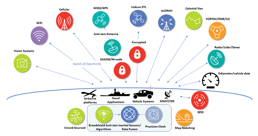
Q: How can I make my PNT equipment resilient against jamming, spoofing and other types of interferences? The key is Integrity and Trust: ensuring the integrity of GPS signals by making them trustworthy. This picture tells the story.

This image shows many references from the external world. But you can also use an internal reference – e.g., an inertial navigation system – to make your system resilient. An INSAn INS or Inertial Navigation System - sometimes used synonomously with IMU is a device used to measure a vehicle's speed, position, velocity, heading and orientation by using an accelerometer and a gyroscope. uses accelerometers to measure acceleration – integrating twice to get velocity and position – and gyroscopes to measure direction. This type of navigation is known as dead reckoning which cannot be spoofed or jammed, but over time errors build up. Occasional updates from external sources can correct these errors, but now you have reintroduced the possibility of spoofing.


