Configure Satellite Positions Based on User-defined Elevation/Azimuth in Skydel
Technical & Application Notes
Introduction
The main goal of this application document is to show users how they can configure satellite positions based on user-defined Elevation/Azimuth in the Skydel software. A MATLAB script and functions are attached to this document to help a user generate a set of Keplerian parameters allowing the GPS satellite to be placed on the required elevation/azimuth in Skyview.
Follow these Steps!
Step 1: Generate Orbital Parameters Based on Satellite’ Elevation/Azimuth
- Run MATLAB script named Main.m
- Define How many GPS satellites you wish to simulate.
- Insert the elevation and azimuth angles in degrees for each satellite.
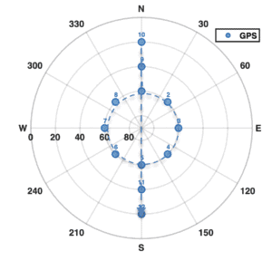
- The script will show the Skyplot of all satellites you have defined in the previous step.
- The script will calculate the Keplerian parameters based on the defined Skyview.
- The script will generate a table with the Keplerian parameters for each satellite and export all parameters in a table called Output.txt in the same directory of the MATLAB script.
- The structure of the Keplerian parameters is as follow:
- PRN: PRN code of the satellite.
- t_oc: Time of Local time.
- t_oe: Ephemeris reference time.
- sqrtA: Root semi-major axis (
- e: Eccentricity (ε)
- omega: Argument of Perigee (w)
- M_0: Mean motion difference
- i_0: Inclination (i0)
- omega_0: Longitude of ascending node (W0)
- omega_dot: Right Ascension Rate (Wdot)
- i_dot: Inclination rate (idot)
- delta_n: Rate of mean motion difference (Dn0dot)
Example (1) – Generate Orbital Parameters of nine satellites located in X-Shape
- Run MATLAB script named Main.m
- Define the number of satellites that you wish to simulate by 9.
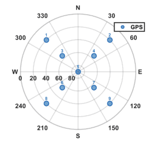
- Enter the elevation and azimuth angles of each satellite as follows:
| Satellite PRN | Elevation (°) | Azimuth (°) |
| 1 | 20° | 315° |
| 2 | 20° | 45° |
| 3 | 55° | 315° |
| 4 | 55° | 45° |
| 5 | 90° | 90° |
| 6 | 55° | 225° |
| 7 | 55° | 135° |
| 8 | 20° | 225° |
| 9 | 20° | 135° |
- You will get a Skyplot, as shown in the following figure.
- The Keplerian parameters will be generated as follows

Step 2: Simulation Configuration
- Open Skydel and create a new configuration.
- Set simulation time to 2020-03-29 00:00:00.
- Set the vehicle position at latitude = 0, longitude = 0 and altitude = 0.
- In the GPS tab, select Signals and enable the PRN you want to simulate.
- In the GPS tab, select Orbits.
- For selected PRN, set the Reference time (GPS) to 2020-03-29 00:00:00.
- Replace the orbital parameters with values available from Matlab script execution (done previously) for each selected PRN.
- Keep other parameters unchanged or force them to 0.
- Repeat for all satellites.
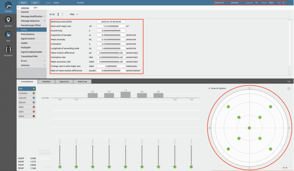
Referring to example (1), Figure 3 illustrates a screenshot of Skydel software after the orbital parameters and the reference time (GPS) (in red boxes) has been modified according to the Orbital Parameters obtained in step (1) and completing the procedures of step (2). You should see the same satellite pattern (in red circle) as in Figure 1 at the Constellations tab of the Skydel software.
Step 3: Run Simulation
- Connect your GNSS receiver and run the simulation.
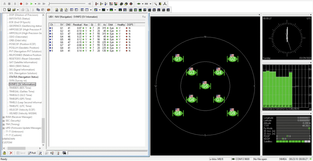
- You should see the same satellite pattern in your receiver’s Skyview. Referring to example (1), Figure 4 is a screenshot of a UBlox receiver, demonstrating the satellite’s pattern in X-Shape as simulated using Skydel software.
Limitations
Please be aware that this simulation method has some limitations as follows:
- Time and position are fixed and forced to the value mentioned in Step (2) section of this document.
- If the GPS receiver uses an almanac for crosscheck of satellite position, that may change the constellation on sky view. Usually, this arrives after 12.5 min in simulation (after the almanac is validated).
- Satellite position will change quickly with time. If you wish to keep satellites in the same positions, you will need to unchecked update satellite position during simulation option under Orbits tab for each satellite.
Several Satellite Patterns can be Simulated Using Skydel
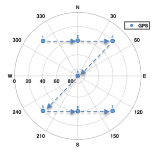
Using Skydel software features and the attached MATLAB scripts to this application guide, you can configure and simulate several satellite patterns based on the user requirements. For example, and not as a limitation, a user can simulate satellites located in Z-shape or phi (F)-shape as shown in Figures 5 and 6, respectively.
Orolia Contacts
Iurie Ilie Technical Fellow
Orolia Canada Inc.
iurie.ilie@orolia.com
Mohamed Tamazin Senior GNSS Architect
Orolia Canada Inc.
Mohamed.Tamazin@orolia.com
November 3, 2021
